Since dabbling with a course on Religious Myths and Worldviews for the past two years as an instructor, I began to view cartography through the lens of a narrative. The lab-coat scientist approach I had earlier, of viewing maps as mere representation of the landforms , now seems like a tip of the iceberg. Mapping physical landscape has historically been a process of storytelling, reporting and often an embodiment of the view of the world.
The opportunity to hear Dr. Ali Asgar Alibhai speak about early Arabic cartography and the seamless blend of travelogues, narrative lore (kissa), and the information from travelers and mariners who have ventured into the outside world. This discussion got me thinking about the cartographic documents from South Asia that I frequently interact with. The worldview from a particular tradition lends itself to the representation of nuances in a mapped area on paper.
The form and presentation of a cartographic document could vary based on the intended audience, and purpose. I was first exposed to the nautical maps from the ancient world, where the crisscross of latitude and longitudes and the artistic wave form to represent the sea, made the comprehension a Herculean task. And then I started looking closely at the maps that chart the territories of personhood or a shared faith in the form of cosmology.

Imagining the earth’s surface as akin to the body extends from the corporeal nature of humans to the resemblance of the landforms and the human body. As the water, soil and atmosphere represent their respective areas on a two-dimensional map, the human body is extrapolated as a map with hollow cavities, water, fire, bile and other components. As a landmass is susceptible to attack, capture and at times destruction owing to the natural forces, the human body also follows these cycles through which it navigates the meaning of life.
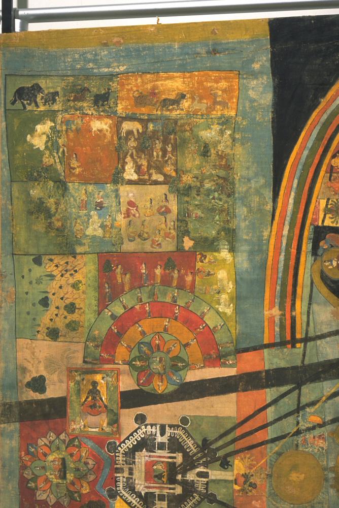
The cosmological map from Rajasthan, presently housed at the Asian Art Museum, (San Francisco) extends human body – landmass association to incorporate the seen (pasyat) and the unseen (apashyat) aspects of life within and outside the physical existence of one’s body. Let us take a closer look at this painting:
The mind and the land
The walled city (?) or nagara depicted in the picture functions as the center of power and the human settlement for this depiction [Plate 1]. The king and queen (presumably) seated in the fortified structure stand for power – both political and divine. Here, the nagara is surrounded by lawns, curated landscape, a small water feature and a garden to its north. To its east (right) is a stretch of cultivated land (kshetra) [plate 3], while to its left (west) is the wilderness (vana) [plate2].

The demarcation of physical land into vana and kshetra is significant for what it stands in actual geography of the mind. The wild thoughts, and wilderness; need to be tamed, while the cultivation needs to be tended to. Corresponding animals and demigods from Hindu lore populate these landforms. Wild animals skirt the rims of wilderness, and numerous multi-armed deities reside in the forested area.

Tamed landscape perpetuates order, while untended wilderness, chaos. And much like the human mind, there is a delicate balance to be achieved, which is achieved in human society as the role of a king (according to 17th century scriptures).
Society and balance
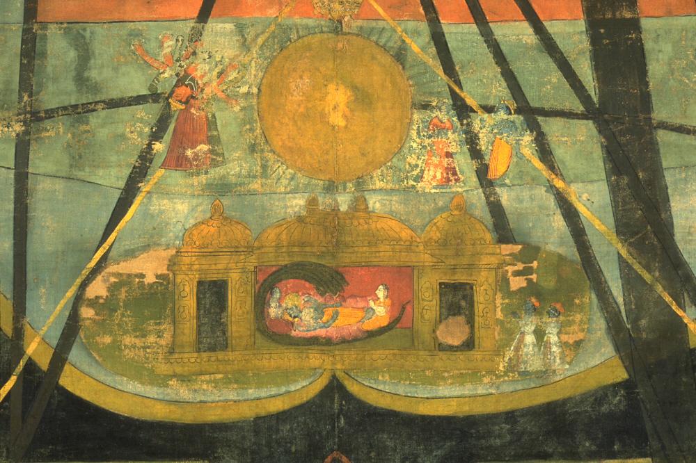
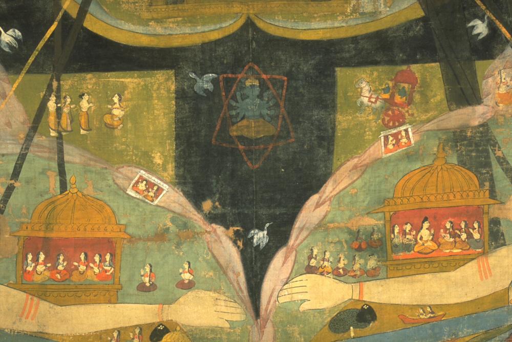
Sun, the source for all energy appears in close connection with Vishnu throughout the Puranas and other works of Hindu literature. The radiating sun is as if the messenger of the gods. If we take the top tier in the painting to mean the celestial realm, the sun and the surrounding area can be the par of visible universe – the sky and the stars. And the yellow lines connect the corporeal beings with the solar energy, and the black lines denote a succession of attributes from the heavenly deities.
Numerous cartographic representations depict a humanized aspect of sun. Some highlight the power radiating from the sun, while some representations feature sun as the other layer/dimension of the represented space. In this chart, it could be taken as a demarcation between the godly and the human realms. This representation thus, adds tiered dimension to the concept of space habited by various beings.
In the depiction of cosmological charts, the hierarchical order in the South-Asian society (as prescribed by the scriptures) comes into play. In this chart, the dvija (twice-born) Brahmin and Kshatriya men are depicted as virtue incarnate. On the right hand side, the Kshatriya depiction comes in the form of a chariot-rider, and the Brahmins as a person instructing a group, to the left. Lotus petals signifying purity of mind and actions encircle the varna forms – almost as if protecting from the outside pollution.
Physical land and physical body
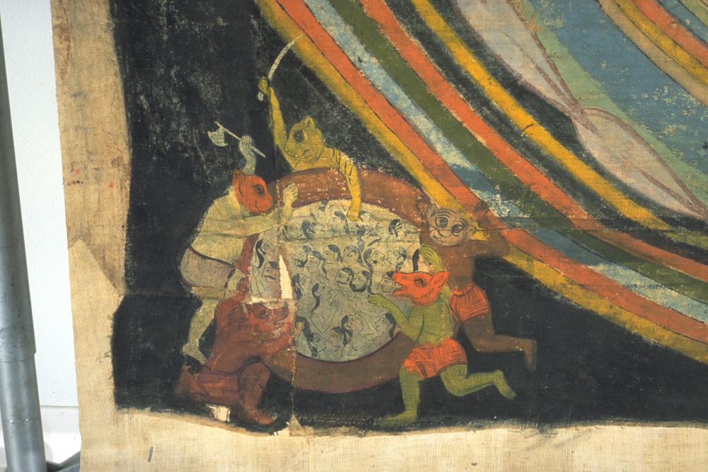
As the complicated line of descent, represented in plate 6, so is the complexity of physical body with its gunas. Although guna theory deserves a separate discussion, for a cursory mention, the sattva, rajas and tamas gunas depicted in different colors form a boundary within which some of the human actions are unfolded. The human being, in turn, is like someone floating in a lake of ether, accompanied by the righteous and the less-righteous (voices inside the head).

The physical body, in turn, is peopled by various elements in various forms and their multiples. The Samkhya School of philosophy among others, furnishes an exhaustive list of tanmatras, indriya and the smallest agents of the physical body and the senses. Notice the circular bulbs on the throat, heart and other areas of the body. These depict the chakras.
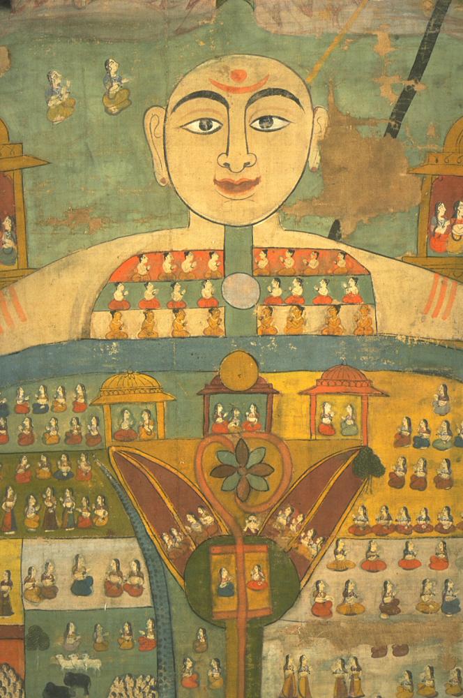
One attains full realization beyond their bodily self, when the adnya chakra blossoms (depicted in plate 8). The kundalini, in the form of a snake draws heavy on a person, which needs to be awakened further. The hydra constellation (ashlesha) reigns on this bodily aspect, as per some texts. All these intricate attributes are in turn encased in a watery hollow with several linings – that is, the physical body.

And in the unknown depths, lies the dark place – hell (naraka) depicted in plate 8.
Mapping the message
In this particular example, the narrative of kingship as godliness, maintaining status (or varna) quo, depicting the popular philosophical and esoteric notions of the world, as well as highlighting the popular realms of heaven, earth and hell is achieved. It is not outlandish to think that such charts were meant for specific demonstrative use, such as in a classroom with dvija male students.
The provenance of this piece as Rajasthan further helps us ascertain the underlying intentions for mapping this complex graphical language in this illustration. Kingship in c. 17th century Rajasthan was a contested territory, and inspiring confidence in people for king as god amongst the living comes off as a common repertoire.
This example is not to say that all maps of the period were riddled with complex esoteric depictions. Some pleasing maps or cartographic illustrations from the time seem more at home with the concept of maps we know today.
Other examples
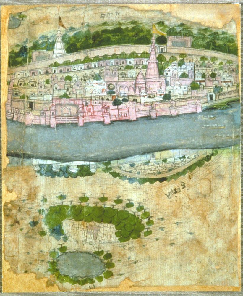
This map from the former kingdom of Kishangarh depicts the venerated city of Mathura on the banks of river Yamuna. Some would argue that this seems more of an illustration in elevation rather than a map. And if you notice on the lower side of the river, the area of Hansganj is represented as upside-down. When viewing from the north, it will appear in elevation. The artist has probably rendered one city as important over the other in this depiction. The viewer can gauge the approximate size of the cities (assuming it is not blown out of proportion) and the landforms around the city. Although not a scaled map, this illustration could help weary travelers of the 17th century CE identify the city (and the labels in nagari script help further).

The map of Kotah depicts the impact of flood in this representation. Accompanied by labels and distinct visuals for various landforms, the map presents a visual narrative of the main river bed, the flood plains, the diverted routes, and the possible (?) destruction owing to flood.
This map, akin to our modern sensibilities of map making, ultimately charts the confines of human activity and interaction with nature on a two-dimensional canvas. Although we do not get a glimpse into the “inner workings” of the humans affected by this territory on the map, humans (with their bodies and minds) connected intimately to the landscape comes to the forefront.
Further Reading:
A presentation on “Cosmogony to Cartography” (opens in a new tab)
D.

Leave a comment